


![[ERROR]: Lack of Women in the Software Industry](https://theechohsmse.com/wp-content/uploads/2024/12/APC_0280-984x1200.jpeg)


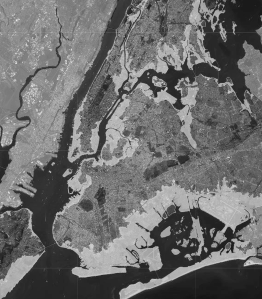
New York City is not built to withstand flooding, yet it is located in one of the most flood-prone regions and was developed atop former streams and marshlands. During heavy rainstorms and storm surges, these effects are clearly visible: Basements and streets flood, subway systems and transportation networks in general are unable to run, and drainage systems clog.
As sea levels continue to rise due to climate change (see The Echo’s previous article “Atlantis Manifested: The Sinking of NYC”), these flaws are becoming a more serious problem. By the 2050s, 37% of buildings in Lower Manhattan are estimated to be at risk from storm surge; by 2100, this number is expected to rise to 50%. Additionally, by 2100, 20% of Lower Manhattan’s streets will likely be at risk of daily flooding due to over six feet of projected sea-level rise. As a city, we will need to adapt our infrastructure to prevent this extreme flooding from having detrimental effects on our community.
Before European settlement, the Lenape people lived in what is now New York City. They had a very deep knowledge of the land and understood the movement and cycles of the rivers. Using this understanding, they built shelters that suited their environment and were able to withstand harsh environmental conditions.
When Europeans first began construction in New York City, they didn’t have nearly as much knowledge of the land as the Lenape and imposed their own architectural styles onto the area, even if these structures weren’t compatible with the environment. The city was built atop wetlands and various streams and ponds used to absorb water in the past, and hard, concrete structures prevented any water absorption.
I talked to Ms. Rasuk, HSMSE’s architecture teacher, about this issue. “For New York City, the major problem with water is that the infrastructure is so old … because the map of New York City, it’s already so built up. And it’s not just built like all the buildings, but at the bottom, there are so many layers that are already built underground,” she said. It’s also difficult to rebuild sections of the city because closing off a part of the city to fix the infrastructure is not viable. “A lot of the European immigrants that came in, they came in with that idea in their head of imitating where they came from, and they disregarded that this was not necessarily their land that they wanted to imitate,” she added.
This reflects a broader issue tied to the movement of different architectural styles, which can also be seen in Mexico, specifically Mexico City. “The Aztecs really understood how to build on top of Mexico because it was just water … and they built an entire city. Like, if you see how the Aztecs built the entire city of Tenochtitlán, it was all on top of water,” Ms. Rasuk said. “But the Europeans came and then they, of course, destroyed all of that … so now that whole area is sinking.”
The Hundred Year Flood is a designation for a flood event that supposedly will occur once every 100 years. “So, the question becomes ‘Are we prepared for something that could be bigger than that?’ And what [Hurricane] Sandy actually showed,” Ms. Rasuk noted, “is that New York City wasn’t really well prepared in some areas to deal with a large quantity of water.” So what can we do about this?
Today, only about 30% of the city’s surface area is composed of absorbent materials. This means that when sea levels rise, there is no place for the water to go in much of the city. Some possible infrastructure solutions include rain gardens, curbside planted pits, and permeable pavement. These are some of the top examples of green infrastructure, which absorbs the water while also providing other positive environmental effects. Programs such as the Bluebelt Program and Cloudburst Hubs preserve natural drainage corridors and enhance their performance. They provide pathways, storage, and filtering for the water. Additionally, LEED certification helps to provide a framework for green infrastructure. For example, rainwater can be used to flush toilets; irrigate landscapes, especially in very hot and dry areas; and provide heating and cooling. All of these systems help to reduce the environmental impact of the building using excess water from rain or flooding.
Different shoreline types are another important factor in urban flooding. Hard concrete structures, such as floodwalls, are intended to prevent water from entering the city by blocking off the coasts. Following Hurricane Sandy in 2012, the U.S. Army Corps of Engineers created a plan to fortify New York City by building various tall floodwalls on the shorelines. Floodwalls, however, create a problem for marine life by taking away marine and coastal habitats and harming the ocean ecosystem. In addition, fortification plans are not a sustainable solution, as rising sea levels will require taller and taller flood walls.
Nature-based shorelines emulate natural habitats through the use of native plants and animals. Certain native grasses such as Switchgrass (Panicum virgatum) and Indiangrass (Sorghastrum nutans) have deep root systems that help to absorb excess stormwater runoff, mitigate the shocks from waves, and provide habitats for marine life such as crabs. Additionally, oysters were a huge part of the New York Harbor for tens of thousands of years. Initiatives such as the Billion Oyster Project aim to reintroduce oysters to the harbor, which help prevent flooding as well.
In general, natural solutions are important for creating places for water to go in our city. When designing a city or building, there should always be a lot of thought put into the site. It is important to build a city with, instead of against, the surrounding ecosystem. Therefore, we should find ways to use the water in our infrastructure instead of working against it.